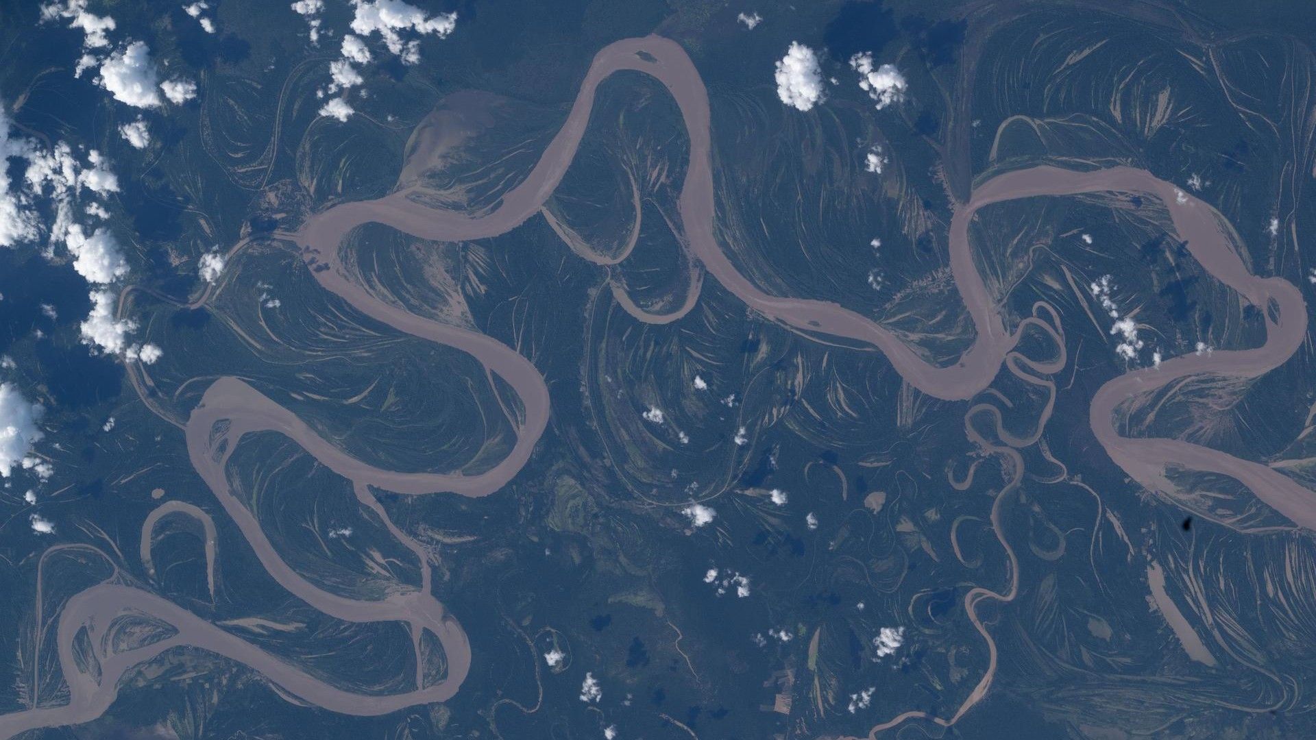
The Amazon rainforest is a vast, living tapestry, and few views capture its intricate beauty like the meandering Ucayali River as seen from the International Space Station (ISS). This stunning image, taken by NASA astronaut Jessica Meir on April 30, 2026, offers a unique perspective on one of the Amazon's most dynamic waterways. But there's far more to this photograph than a pretty picture. Dive into these 10 facts that reveal the science, history, and significance behind this space-based snapshot.
1. The Ucayali River's Serpentine Path
From space, the Ucayali River appears as a twisting, snake-like ribbon cutting through the dense green canopy of the Peruvian Amazon. Its dramatic meanders are not random; they result from natural geomorphic processes where the river constantly reshapes its course by eroding the outer banks and depositing sediment on the inner curves. This creates an ever-changing landscape that astronauts can witness in real-time. The river stretches over 1,100 miles (about 1,771 km) from its source in the Andes to its confluence with the Marañón River, where it forms the Amazon River proper. Satellite images like Meir's help scientists track these shifts, monitor erosion, and understand how climate change might influence flood patterns.

2. Captured by a Trained Eye: Astronaut Jessica Meir
NASA astronaut Jessica Meir, a marine biologist and experienced spaceflyer, used her scientific background to frame this photograph. While on the ISS, astronauts often take Earth observation images as part of daily life and science. Meir’s training allows her to identify key features, like the Ucayali’s oxbow lakes and cutoffs, which are visible in the image. Her photograph serves both as art and data, offering researchers a high-resolution, real-time view of a remote region. This image is part of a larger collection used to study deforestation, river dynamics, and even cloud patterns over the Amazon.
3. Part of the World's Largest Rainforest
The Ucayali River runs through the heart of the Amazon rainforest, the most biodiverse terrestrial ecosystem on Earth. This region, spanning eight countries, houses an estimated 10% of the world's known species. The river itself is a lifeline, providing water and nutrients that sustain countless plants, animals, and indigenous communities. From space, the forest appears as a uniform green carpet, but in reality, it's a patchwork of habitats: floodplain forests, terra firma, and river islands. Astronauts often remark on the ethereal beauty of the river's reflection of sunlight, a testament to the Amazon's role in regulating the planet's climate.
4. A Vital Artery for the Amazon Ecosystem
The Ucayali is not just a river; it's a dynamic ecosystem itself. Its waters carry sediment from the Andes, enriching floodplains and creating fertile grounds for agriculture and wildlife. Fish migration depends on seasonal floods, which the river's meanders facilitate. Birds, pink river dolphins, and jaguars all rely on this waterway. The river also acts as a natural corridor, connecting the Andes with the Atlantic Ocean. Space images help ecologists map these connections, especially in areas hard to reach by foot or boat. The Ucayali's color varies with sediment load—muddy brown during wet season, clearer when flow slows—offering clues about erosion upstream.
5. How Space Photos Aid Scientific Research
Photographs from the ISS, like this one, are more than stunning visuals—they are crucial scientific tools. They provide a unique perspective that satellites often miss, especially oblique angles revealing river depth and bank structure. Researchers use them to measure river width, detect changes in meanders, and even identify illegal mining or logging activities. Unlike automated satellite imagery, astronaut photos can capture transient phenomena like flood pulses or smoke from fires. This particular image of the Ucayali helps validate models of sediment transport, which are vital for predicting how rivers respond to climate change and deforestation.
6. The River's Striking Color and Reflection
In the photograph, the Ucayali River appears as a bright, almost metallic ribbon against the dark green forest. This effect is due to sunlight reflecting off the water's surface. Depending on the time of day and angle, this reflection—called sunglint—can highlight subtle features like water currents or floating debris. Astronauts often wait for optimal lighting to capture these images. The river's color also changes: during the dry season, it may appear more green or brown from algae and sediment; in wet season, it can turn a muddy tan. These visual cues help scientists track seasonal cycles in the Amazon basin.
7. Similar Iconic Images from the ISS
While this photograph of the Ucayali is unique, it joins a long tradition of iconic river images taken from the ISS. Rivers like the Amazon, Nile, and Mississippi have all been captured by astronauts. Each image tells a story of geology and human impact. The Ucayali's meanders echo those of other classic meandering rivers, such as the Yellow River in China. By comparing these images, scientists can study river patterns across different climates and environments. This particular photo, released as Space photo of the day on April 30, 2026, sparked public interest in how Earth's rivers are constantly evolving.
8. Importance for Local Communities
More than 300,000 people live along the Ucayali River, including indigenous groups like the Shipibo and Ashaninka. For them, the river is a primary source of food, transportation, and fresh water. Space images help monitor water quality, especially the spread of sediment and pollutants from mining or agriculture. These photographs are also used in educational programs, connecting remote communities to global science. The river's seasonal floods, visible from space, affect housing and crops, making satellite data invaluable for planning. Astronaut images provide a high-level view that complements ground-level knowledge, fostering collaboration between scientists and indigenous leaders.
9. Environmental Challenges Seen from Orbit
The Ucayali region faces threats from deforestation, illegal gold mining, and climate change. In some parts of the Amazon, rivers like the Ucayali have become darker due to increased sediment from mining runoff. Astronaut photos can reveal telltale signs: turbid plumes, exposed sandbars from dredging, or fragmented forest edges. This image, taken in April 2026, may show the start of the dry season when human activities intensify. By monitoring these changes from space, researchers can lobby for conservation policies and track the effectiveness of protected areas. The Ucayali River is a sentinel for the health of the entire Amazon basin.
10. The Future of River Monitoring from the ISS
As the ISS continues operations, astronauts like Jessica Meir will keep capturing images that advance our understanding of Earth's rivers. New technology, such as higher-resolution cameras and automated tracking, promises even more detailed observations. The Ucayali photograph is a glimpse into a future where space-based monitoring becomes routine. Data from these images can be combined with drones and ground sensors to create comprehensive models of river behavior. For the Ucayali, ongoing observation will help predict meander cutoffs, flood risks, and ecosystem changes. Ultimately, this single snapshot reminds us that the most profound discoveries often come from simply looking down at our planet from above.
Conclusion: The April 30, 2026 image of the Ucayali River from the ISS is far more than a pretty space photo—it is a window into the dynamic, fragile, and vital world of the Amazon rainforest. Each meander tells a story of geology, each reflection hints at depth and flow, and every view from orbit underscores our responsibility to protect these natural wonders. Whether you're a scientist, a student, or simply an admirer of Earth's beauty, this image invites us to think about how rivers connect the mountains to the sea, and how we all share this single, spinning planet.